Tuesday, January 20, 2015

Where LB Traffic Collisions Occur

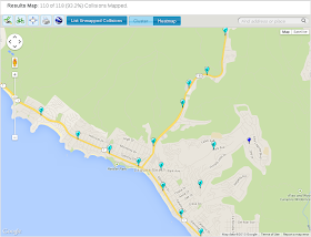
These charts show the location of vehicle collisions around Laguna Beach as compiled by the Transportation Injury Mapping System. Each chart (click to enlarge) shows the number of recorded collisions, the location, the mode of transportation for eleven years 2003-2013.

The first three charts show the hot-spots around Laguna where collisions occur most frequently for all modes of transportation in all circumstances.  The data shows most collisions are concentrated on South Coast Highway and Laguna Canyon Road. The traffic violation cited most often is Unsafe Speed, the most frequent collision type is Rear-End.

South Coast Highway / 1362 Collisions / All Modes / 2003-2013

Laguna Canyon Road / 1362 Collisions / All Modes / 2003-2013

Violation: Unsafe Speed 43%, Type Collision: Rear-End 44% most common


The next four charts show collisions are concentrated along state highways no matter the mode of transport. The pedestrian detail shows collisions that occured in the Hip District with case details available for each incident as mapped by the TIMS system.

Pedestrain Collisions


Pedestrain Detail


Bicycle Collisions


Motorcycle Collisions
 

Tuesday, January 6, 2015

Office of Traffic Safety Issues LB Report Card

The California State Office of Traffic Safety compiles traffic safety statistics for cities state-wide and ranks cities according to the number of injuries and fatalities caused by vehicle collisions. Cities are ranked from safest to most dangerous by comparing the number of traffic collision injuries and fatalities recorded in each city. 

The rankings are adjusted by the number of miles driven and by the resident population of each city. (The rankings are not adjusted for the number of vehicles occupying the city). The rankings are organized for different transport categories like walking, cycling, motorcycling, driving and by the influence conditions that cause the collision like speeding, alcohol, visibility, and hit-and-run. 

Each city is ranked in each transport category from safest to most dangerous.  The charts following are a visual interpretation of the OTS data showing the level of danger for four beach cities from the latest OTS data available. The charts were compiled for pedestrians, bicyclists, motorcyclists and by the influence of speeding on traffic injuries and fatalities.


Laguna Beach consistently ranks over the 90th percentile for the most dangerous city in these categories among the four beach cities (it doesn't get better for alcohol, hit-and-run, DUI as influence factors). In the years to come a comparison will show if this trend persists.  -LS