Thursday, April 9, 2015

The Proposed LCR Road Re-alignment Alternatives A-F

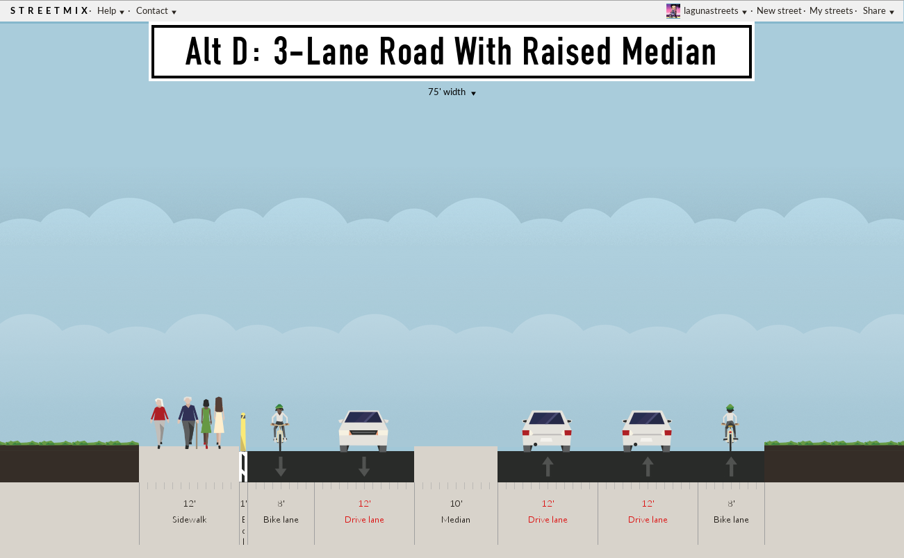
To meet motorist demand inevitable for Laguna Beach the city is reviewing a re-alignment for Hwy 133 Laguna Canyon Road. Alternatives A-E are proposed by the city consultant, Alternative F is proposed by the community.


Design Options: Multi-use Trail, Transit Lane (Dedicated)


Design Options: Multi-use Trail, Transit Lane (Dedicated)


====================


133 Task Force Proposal

Balanced Mobility Concept
  
Background Story:

Alternatives A-E were ranked by the city consultant for success by meeting a single criteria: the alternative that reduces car traffic delay the most wins (pg 24 of the Assessment).

Alternative F as proposed by the 133 Canyon Task Force moves the cycle-track from the highway into the wilderness park where it cannot serve residents across the highway.

Alternative F for 2030 seeks to balance all transportation modes and service the residents of Laguna Canyon Road.  This plan seeks to move people not just cars.

Alternative G is the gender-segregation option. Pink-Zone is inspired by the accident statistics showing the overwhelming majority of accidents are caused by men. See UK's Sheilas' Wheels here.


References: 

"Laguna Canyon Road Corridor Improvement Assessment (El Toro Road to Canyon Acres Drive)", RBF Consulting, 12 August 2014.

"Laguna Canyon Road Corridor Improvement Assessment (El Toro Road to Canyon Acres Drive)", RBF Consulting, 19 August 2014.

"Vision Laguna Final Report and Strategic Plan", December 2001.

Saturday, March 21, 2015

Monterey Drive Alternatives

On Tuesday 17 March LB City Council approved the roadway configuration shown in Alternative 2. For a host of reasons Alternative 1 is safer and the preferred alternative by neighborhood residents. Among the reasons are to combine vehicles with similar speeds in a shared lane and improve eye-contact with all roadway users, even dogs.
Monterey Drive at Jasmine Street before modifications
Shared unmarked pedestrain buffer

Resident preferred Sharrow separate walkway

Council selected shared multi-use bike/ped lane

Note: Traffic on Monterey Drive is one-way northbound.  -LS

Thursday, March 5, 2015

How to use Sharrows

Manhattan Bike Safety Sign, credit Drizzle Studios, Laguna Beach

Sharrows are reminders!

For motorists: the roadway is shared.

For bike riders: the safest lane-position.

Don't ride the  door-zone of parked cars like in this crash test.


Drive Safe
Ride Safe

Friday, February 27, 2015

The OpEd Unfit to Print

How Laguna Beach Got its Sharrows

What 8 years of community organizing failed to accomplish the LB City Council achieved by decree: 'Yea it Shall Be, Yea Verily it Shall Be Done!' The long awaited alternative bike-route through Laguna Beach will be completed in February. Every manner of community bike-rides, task force meetings, public workshops, firesides, potlucks and drum-circles tried but failed to inflate the agenda bill. But fear of litigation for compensatory damages (French, Pettis, Deem, Fitzpatrick, Colvin, the homeless ) brings municipal focus and commitment like a bike end-O. Last October our city committed to finish a bike-route, any bike-route, to improve street safety for LB cyclists.


But damn the torpedoes, design process, engineering review, stakeholders and those safety rankings from State collision reports, it's political engineering that gets stuff done in Laguna Beach. If you think these bicycle Sharrows are a miracle, wait till CalTRANS plows the Canyon HOV lane and the merry-GO-roundabouts. How 'bout a LCR bi-lingual bike and pedestrian pathway for Parents Without Partners?

Four of five OC Newspaper would not print this commentary.       -LS

Sunday, February 22, 2015

Tuesday, January 20, 2015

Where LB Traffic Collisions Occur

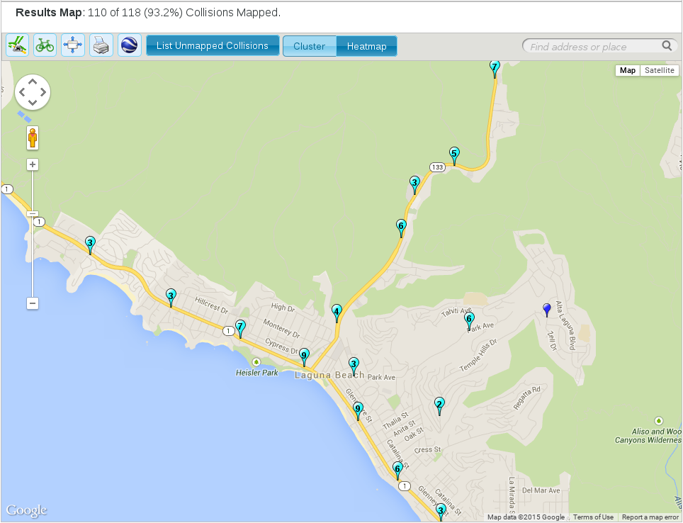
These charts show the location of vehicle collisions around Laguna Beach as compiled by the Transportation Injury Mapping System. Each chart (click to enlarge) shows the number of recorded collisions, the location, the mode of transportation for eleven years 2003-2013.

The first three charts show the hot-spots around Laguna where collisions occur most frequently for all modes of transportation in all circumstances.  The data shows most collisions are concentrated on South Coast Highway and Laguna Canyon Road. The traffic violation cited most often is Unsafe Speed, the most frequent collision type is Rear-End.

South Coast Highway / 1362 Collisions / All Modes / 2003-2013

Laguna Canyon Road / 1362 Collisions / All Modes / 2003-2013

Violation: Unsafe Speed 43%, Type Collision: Rear-End 44% most common


The next four charts show collisions are concentrated along state highways no matter the mode of transport. The pedestrian detail shows collisions that occured in the Hip District with case details available for each incident as mapped by the TIMS system.

Pedestrain Collisions


Pedestrain Detail


Bicycle Collisions


Motorcycle Collisions
 

Tuesday, January 6, 2015

Office of Traffic Safety Issues LB Report Card

The California State Office of Traffic Safety compiles traffic safety statistics for cities state-wide and ranks cities according to the number of injuries and fatalities caused by vehicle collisions. Cities are ranked from safest to most dangerous by comparing the number of traffic collision injuries and fatalities recorded in each city. 

The rankings are adjusted by the number of miles driven and by the resident population of each city. (The rankings are not adjusted for the number of vehicles occupying the city). The rankings are organized for different transport categories like walking, cycling, motorcycling, driving and by the influence conditions that cause the collision like speeding, alcohol, visibility, and hit-and-run. 

Each city is ranked in each transport category from safest to most dangerous.  The charts following are a visual interpretation of the OTS data showing the level of danger for four beach cities from the latest OTS data available. The charts were compiled for pedestrians, bicyclists, motorcyclists and by the influence of speeding on traffic injuries and fatalities.


Laguna Beach consistently ranks over the 90th percentile for the most dangerous city in these categories among the four beach cities (it doesn't get better for alcohol, hit-and-run, DUI as influence factors). In the years to come a comparison will show if this trend persists.  -LS


Wednesday, December 31, 2014

Saturday, December 27, 2014

BMW DriveNOW RideShare

Want to boost your image?


 In Berlin, Munich, Hamburg, Cologne, Dusseldorf  San Francisco and coming to Oakland BMW offers an electric car-share program. DriveNow brings all-electric BMW's to California streets. Locate and select the Mini or sedan model of your choice by smart phone. Unlock get-in and drive to your destination, pay-by-the-mile.


In a hurry? Register for DriveNow here.