Friday, December 23, 2016

Hot Spots on Laguna Canyon Road

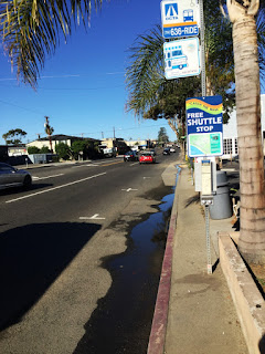
See any pedestrian bike or rail traffic on this road? One solution to Laguna's car traffic and parking congestion is building the mobility modes we don't presently use, like walking biking bus and rail. 


Is this a bikelane?  Caltrans thinks so they designed it, they maintain it yet few are brave enough to use it.


Gee Caltrans thanks for the written instructions. SHARE THE ROAD they say, or maybe my bike tires are too fat?


https://www.facebook.com/stuffdutchpeoplelike/?hc_ref=SEARCH
Stuff Dutch Moms Like Facebook


SHARE THE DRAIN


Would Olif and his kids ride LCR?


Here's the truth test, if our roads were good as those in Holland Denmark and Germany you would see this at Anneliese Schools.

Build it and they will come.   -LS

Friday, December 16, 2016

South Laguna the Stepchild of LB

To reduce auto traffic congestion in Laguna Beach the city should take action to build travel modalities as alternatives to the automobile, they are walkways, bikeways, transit stops and their amenities.

This is a Google Map view at Aliso Creek - a primary ecological feature of South Laguna. In 1987 South Laguna was annexed to Laguna Beach in order to share and benefit from the same city services as Laguna Beach - at least when viewed on paper. The physical boundary between the two remains unchanged, the only safe means for South Lagunan's to travel north-south is by motorized vehicle or Trolley on PCH or risk walking on the roadway on both sides of PCH.


This picture shows the Aliso Pedestrian bridge over South Coast Highway (PCH). Notice the only route north-south to South Laguna is though this choke point. Let's take a closer view from the street at the bridge.
Here is the street view northbound on PCH at the bridge. From a cyclists perspective the fog-line (not a bikelane) disappears into a Caltrans cheese grader, from a pedestrian's perspective there are no provisions at all. Weekend mornings you may see dog-walkers sharing the #2 lane with weekend traffic passing here at 50mph (posted speed is 40mph).


Here is the same street view on PCH at the bridge looking southbound. In 2001 a pedestrian was struck and killed north of Ruby's diner where the roadway is less dangerous than here, still fifteen years later nothing was done to improve pedestrian safety there nor here. Across the street there is no sidewalk - it ends the Montage Resort. Were it not for the Montage there would be no sidewalk at all.


For pedestrians or cyclists from South Laguna the safe route to visit Gelson's, CVS, Sinaloa or Ruby's since 1987 remains:
  • Walk in the fog-lane down PCH
  • Aliso pedestrian tunnel to Aliso Beach
  • Beach shorebreak to Aliso Pedestrian Bridge
  • Aliso Circle to Wesley Drive
  • Wesley Drive to shopping center
  • Sidewalk to Ruby's and points between.
 Meanwhile cities elsewhere implement alternatives to motorized congestion.
-LS

Friday, December 9, 2016

Poor Mans Transit Station Laguna Beach

On the left are modern transit stops in Tampa Florida, on the right is Laguna Beach. Tampa's median household income is $47,000 Laguna Beach is twice that  $94,000. Consider also Tampa is dead last in median household income for largest US metro areas.        -LS

LB Transit Station 5:00pm
 

Sunday, December 4, 2016

LB PCH Transit Measures Up


Homer says to reduce Laguna's auto congestion give commuters an alternative to the automobile, build the infrastructure to offer travelers better options.  Here is a transit stop in Newport Beach (corrected). 
PCH at Beverly looking South


Here is the transit stop in Laguna, Beverly at PCH


Modern transit stops provide seating, shelter from the elements is obligatory and offer commuters transit route and schedule information.


PCH at Beverly looking North


This is transit Laguna style on-the-cheap, no seating no shelter and a complementary morning bath when the bus arrives. A planter box a palm tree and a transit sign all share the passenger sidewalk. What was the vision that supported this design?  What prohibited Laguna from implementing designs equal to the standards set by our neighboring towns?


-LS

Friday, November 25, 2016

LA Thanksgiving Traffic ABCNEWS


Left unchecked this is the Caltrans solution for Laguna Beach. There's a better way.


Tanaro River Piedmont Northern Italy, there is a connection.
-LS

Saturday, November 19, 2016

Tuesday, November 15, 2016

Friday, November 11, 2016

Raised Bikelane for Canyon Acres

Common in Denmark, Germany
LCR to Canyon Acres and beyond

Laguna Canyon Road is crowded, here's a way to provide two more mobility modes for both residents and visitors, from Canyon Acres to downtown Laguna. This raised bike- lane common in Denmark Holland and Germany and adopted in San Francisco is used to separate ped, bike, parking and traffic on the same street. The topography on Laguna Canyon road is already correct for this design, simply add bollards and pavement paint.  Meanwhile if your conviction is adding more autos to the crowded mobility mix, the Auto Mobility convention starts Monday at the LA Convention Center, notable is the The Sharing Strategy event at 11:00am Monday.       -LS

Monday, November 7, 2016

Measure LL Teams with KK

Did you get one of these in the mail?  The YES on LL and KK  Locals want you to know the medical benefits of cannabis now relieves Laguna traffic congestion too. The Bogus campaign flyer says:
  • City Leaders (cheerleaders?) endorse LL and KK (a ballot measure only)
  • Measures LL and KK are important for Laguna's future
  • Measures LL and KK will knock-out traffic in Laguna Beach
  • Will protect Laguna Beach from more tourists
  • Protect Laguna Beach from state government overreach
  • Measure LL raises millions from tourists, then
  • Measure KK buys trolleys roadway improvements and a park-and-ride
  • Measure LL and KK ensure medical access for seniors and veterans
These guys are so desperate for a LL/KK two-fer they even promote Complete Streets.

The facts about Measures LL and KK remain as follows:
  1. Measure LL is an additional 2% hotel tax on 6% of Laguna's visitors, the money enters a city slush fund to be spent in any way the city chooses.
  2. Measure KK is poorly written legislation for medical cannabis, the outcome is dependent on passage of California Proposition 64 Marijuana Initiative. 
  3. These measures have nothing whatever to do with solving traffic congestion.
-LS


Sunday, November 6, 2016

The Role of Mobility Priorities


Newport Beach shows their 2014-2015 annual budget is $165 million with an increased property tax of 5%, increased sales tax 4.8%, and increased bed tax 6.1% that year. Their Public Works expenditure was $33 million. Meanwhile this senior was photographed last week sitting on the sidewalk while waiting for the Route1 bus, turns out the bus was stuck in Laguna traffic and late. The bus route provides a sign marker but no transit shelter not even a waiting bench to sit down.  Newport Beach is home to fine automobile dealerships like Ferrari, Maserati AND Lamborghini so maybe NB Public Works could reevaluate their priorities?
 -LS

Wednesday, November 2, 2016

Completing the OC-Loop

Bet you didn't know a 66 mile loop exists to provide alternative mobility to the automobile in the heart of Orange County? Here's the OC-Loop in a nutshell:  A 66-mile paved loop connecting 650,000 residents and 340,000 jobs within one-mile connections to 17 Orange County cities, links to 200 city parks and access to 180 schools. The loop is 98% complete but OC Parks is inviting residents to join a public workshop to design the remaining 2%.
Click for details


Where: Yorba Linda Community Center, 4501 Casa Loma Ave, Yorba Linda 92886
When: Tuesday 15 November 2016 6:00 - 8:00 pm
Details: OCTA Website OC Loop Invitation


Westminster is broke while Laguna has cash reserves, yet Westminster is building alternative bike routes to connect with the OC-Loop. With better planning Laguna Beach could join the OC-Loop network by completing Old Laguna Canyon Road, from James Dilley Park to Lake Forest and beyond.
-LS 

Monday, October 17, 2016

How to Hire City Consultants

Regional Active Transportation Forum October 14, Garden Grove, credit M Martinez

Last Friday 10/14 the Orange County Council of Governments (OCCG), the Southern California Association of Governments (SCAG) and the Metropolitan Planning Organization (MPO) hosted another Active Transportation Forum, this time in Garden Grove. The agencies share a common mission, to prepare our county planning documents to qualify for state and federal grant funding for new transportation infrastructure, that means if their planning documents are not in order, they cannot compete for the funding.  In 2016 there was $79 million available in Federal CMAQ grant money up for grabs yet Laguna's General Plan Circulation Element was updated once in the last 42 years. Councilwoman Diana Carey showed the audience six essential preparations her city of Westminster used to qualify for funding and prepare for Active Transportation, Laguna doesn't meet any of the six.


Other Orange County communities are struggling to meet ever-increasing vehicular traffic so the Departments of Public Health, MPO and SCAG are cooperating to redesign urban settings from car-centric back to livable environments and public space for people. Active Transportation plays a role by moving people not just cars, how we plan and design our public space makes an impact on the economic, mental, physical and social health of city inhabitants.


Our speaker Hasan Ikhrata Executive Director of SCAG had advice for city institutions. When hiring planning consultants Hasan said "provide choices, don't direct options" meaning ask consultants for best design choices, don't specify the requirements to win the job.  For example to update the Laguna Beach Specific Plan the hired consultant will read these instructions:  Balance the need to preserve the existing village character and pedestrian orientation with the objective to accommodate the traffic and parking demands generated by tourists.   Wha?  That's like saying preserve our pedestrian orientation but hide the parking garage. What should a consultant design? A parking structure? A Gateway Opportunity?


Our City sells the illusion that if we get the parking just right our traffic congestion problems go away, if we hire the right consultant they can work this out 'cuz they are experts. It just ain't so. Laguna should hire experts for demonstrated best practices, not for options the city manager prescribes. If our city council cannot exercise oversight on behalf of residents (they don't) then it's time for new leadership from a council person who gets it. Judie Mancuso listens to consultants, she knows the difference between compensating for expert advice and paying for a jobs program. Judie knows to qualify for grant funding we need to get our General Plan in order and up to date.

Our keynote speaker was Founder and Director Daniel Iacofano of MIG Consulting -yes that MIG. Daniel explained a benefit of Active Transportation is Real Estate Value Capture:  to revitalize any business district and raise property values, you reduce automobile traffic and increase walk-in traffic. Parklets done right are a means of creating community space that people are drawn to, hence walk-in traffic.

Caltrans, OCTA and SoCal cities shared good company at the event, Laguna did not send a city Rep.

-LS

Wednesday, October 12, 2016

Get-Moving OC Forum #2 Results

The I5 Bottle-Neck Problem Depicted for Toll-Road Solution
Orange County expects another 400,000 inhabitants between now and the year 2035. During that time the Orange County Transportation Authority will administer $14.8 Billion in Measure M funding to alleviate traffic congestion but the delay times are still projected to increase 64% if nothing more is done. Fortunately the Transportation Corridor Agency (TCA) that brought us the 241 and 73 Toll Roads have begun a rigorous program of public uptake to determine 1) if I5 has a congestion problem, 2) if a community consensus can be found 3) who holds the keys to gain community support for making infrastructure "improvements".  In Public Forum #2  held 5 October 2016 the TCA in collaboration with Caltrans and OCTA (Orange County Transit Authority) revealed 14 Ideas for road infrastructure projects, consisting mainly of Toll Roads and widening of existing roads. The following are highlights of the TCA plan.

Special Consultant Conclusions:
  1. A community-wide agreement on I5 solution is unlikely
  2. There is a high level of agreement that I5 has a congestion problem
  3. Due to 1. elected officials are perceived as the most appropriate persons to develop (I5) solutions
What the 14 Ideas (roadway modifications in the map) show
  • The single modality considered for moving people is automobiles
  • The single requirement for improving transport is car delay time (LOS)
  • The single performance criteria for improvement is reducing delay time
  • Among the roads modified is Ortega Highway 74 as 4-lanes
  • Idea #7 widens 133 Laguna Canyon Road and arterial highways
  • Toll-Road costs start at $100 million per mile 
  • Average reduction in delay time is a meaningless 1-5 percent.
-LS

Thursday, October 6, 2016

Homer's Rules of Mobility

Homer plans his day
 Four simple mobility rules:


Trip distance 0-1 miles: Walk
Trip distance 1-5 miles: Bike
Trip distance 5-10 miles: Bus
Trip distance 10-100 miles: Car

Friday, September 30, 2016

Homer Solves Traffic Congestion Overnight

Homer the LB Homie lives downtown Laguna but relies exclusively on his car to get around. Here's how he plans his daily trips.


Homer's Brain on Cars

If Homer chose his travel mode based on the trip- distance from his apartment, then his mode trips might look like this. 

Homers Brain on Complete Streets Policy

Walk:

Medi's Printshop
Bank of America
Wells Fargo
US Bank
The Grove
Marine Room
Alessa's
Lumberyard
Sawdust Festival
Festival of Arts

Bike:

Laguna Coffee
Broadway Pharm
Post Office 
City Hall
Whole Foods
Ralphs
Zincs
Ganahl Lumber
Laguna Books
Dem Club
Friendship Shelter
Adolpho's
Gigi's 
Ruby's
Tivolis 

Bus:

LCAD 
Laundromat
Gelson's 
Pavilion

Car:

Costco
UCI
Larry's Lumber
Ganahl Lumber

If Laguna's homies used all four mobility modes Laguna would solve traffic congestion overnight. No tiresome agenda bills, no traffic cops, no Trojan Horse and no Gateway Opportunity at no cost to the city of Laguna Beach. Will our homies do the right thing?        -LS

Sunday, September 18, 2016

Laguna is Going for Gold

2007 Pedestrian Collisions
Dave Hansen referees in "Laguna Battles for Gold in Street Injuries" showing the pedestrian injury/fatalities for Laguna Beach is bad and getting worse. Dave explains that accident records show injury/fatalities compiled in police records since 2007 are not Riverside lunch-bag day-trippers, it's Lagunans too. It's not 3:00am July 5th but Wednesdays in December.
2014 Pedestrian Collisions

An LB City Council member recently said, Laguna's traffic congestion is caused by pedestrians.........  While pedestrians may remain the inconvenient truth for motorists, there is something seriously wrong when council members wear their Consciousness like a traffic cone.

The graphics show where pedestrian collisions occurred, in 2007 there were 19 collisions and 1 fatality, in 2014 there were 33 collisions and 2 fatalities, a 74% increase.   -LS

Tuesday, September 13, 2016

Low Cost Housing for Laguna

Laguna Canyon Nada
Good news for car owners, soon you won't need one. In San Diego's Little Italy a new development has eliminated parking requirements in order to encourage car-free living and reduce the cost of rents.

In WSJ Ester Fong's endeavor to show both sides of the argument she is very successful, so thorough we completely loose the purpose for building low-cost housing. Rather we take the parking-brawl outside for a street-fight in the Commentary section because when it comes to urban planning, everybody is an expert.


So far 61 experts wrote commentary because every writer knows their piece of the elephant. Some writers remark how such a lefty progressive idea couldn't possibly work in Houston, others write how relaxing parking requirements failed in Portland. Yet others say let market forces determine housing densities so "keep-a you hands off my kaaa".  If free-market forces are such a good thing, why does Laguna suffer under the summer traffic congestion it experiences now? Maybe existing regulations and free-market forces - the availability of cars-on-the-cheap have something to do with it. In 2013 a quarter of US renters spent half their monthly income on housing made less affordable due to parking requirements.

Commentary can be misleading. The statements following Fong's piece distract the reader from the central idea: how relaxing parking regulations benefit affordable housing. If Ester Fong combined Complete Streets Policy with urban planning, then a community of low-cost housing connected by transportation free of parking costs would emerge.  Low cost housing development is sorely needed by the art community in Laguna Beach, in neighborhoods long ignored. 
-LS

Wednesday, September 7, 2016

Laguna's Parking Requirements Uncool


It's not the 60's Man ....  so why regulate by old-rules?  Laguna like Ottawa should get hip - we have a Golden Opportunity not a Gateway Opportunity.

Saturday, September 3, 2016

Steps to Complete Streets: Test and Verify

Paris is converting city center Carfree


Step 5. Influence Factors

Paris is removing cars from the city downtown and building a massive pedestrian zone, just as Time Square NYC did. As a public-outreach gesture the city is testing the actual street closure with more than a high-priced consultant workshop, they simply close the Avenue des Champs-Élysées and monitor public reaction. Plan, build, test and tweek, the simplified steps to a Complete Street.

-LS


Saturday, August 27, 2016

Latest Collision Map for Laguna PCH

Collision Maps for 2014-2015

The Office of Traffic Safety (OTS) collects collision data from the California Highway Patrol and municipal police departments for all highways and surface streets in California. The Transportation Injury Mapping System (TIMS) established by researchers through SafeTREC at the University of California Berkeley provides data and mapping analysis tools for traffic safety related research, policy and planning. In collaboration with Google Maps the collision data is presented as blue push-pins on the Google satellite views you see below. The three maps show the collisions for the latest data available from full years 2014-2015.  The collision data is immature for the 2014-2015 period, expect the number to increase above those shown here.

Click to enlarge
The first map shows the number and locations of collisions of all types recorded for South Coast Highway (PCH) through Laguna Beach. The bike-routes through Laguna Beach are colored green.


Click to enlarge

The second map shows all the recorded bicycle collisions on surface streets for Laguna Beach in the 2014-2015 period.


Click to enlarge


The third map shows the recorded bicycle collisions on PCH in Laguna Beach for the 2014-2015 period. The average number of these bicycle related collisions is 6 per year. When the OTS database for 2014-2015 is complete, expect the number of collisions shown to increase. 

-LS

Friday, August 26, 2016

Why We Pay Consultants

Forest Avenue 1938
According to MIG Consultants quote:


HEIGHT ANALYSIS AND EVALUATION

Downtown Laguna Beach has a unique eclectic character created by a series of architecturally varied one-and two-story buildings.This character exists because downtown Laguna Beach is a remnant from an era where cars were not the typical mode of transportation. Walking and bicycles were more commonly utilized and thus, these low-slung buildings were originally designed to be a comfortable pedestrian scale.


-LS

Friday, August 19, 2016

3-D Tools for Street Visualization

https://vimeo.com/136672997
4-Ways to Road Diet (click here)
Here are some design tools from Cupola Media useful for visualizing roadway designs before mistakes are made during installation. As Laguna rethinks the purpose of public parkletts consider these tools for active street design, before the next Parklett Rodeo kick-off in Laguna Beach.

Animation I shows 4-ways to reduce traffic congestion with a road diet. Two of these are directly applicable
to Laguna Canyon Road and
Temple Hills Drive.
Street Design brought to life in 3-D Animation

https://dl.dropboxusercontent.com/u/3329542/PPS_Hailey_3.0_WebGL/index.html
3-D Animation of Hailey Idaho, (click here)
Annimation II shows different roadway interventions for traffic calming techniques. The entire process is put in motion, the pedestrians cyclists and vehicles move, different cameras are chosen and move along the roadway. You apply all these elements to the scene in Animation III.
 
Here's the awesome part, this is where you design the roadway yourself. In Animation III  you choose the roadway elements, choose different cameras, and set the entire scene in motion with simple mouse clicks. Try it! Click on the animation to participate in a full-screen experience. You Drive!

What if Laguna Beach made animations of Forest Avenue, Laguna Canon Road, PCH?


All this is made possible with the collaborative genius of Jeff Speck, Spencer Boomhower and Unity WebGL technologies at Cupola Media.

-LS

Monday, August 15, 2016

LCR Planning Study

Task 2.14 Deliverable from MIG Consulting
Latest deliverables for the Laguna Canyon Planning Study from MIG Consulting, 66 pages condensed to bullet form on mobility planning (traffic) measures:
  • Task 1.6 Deliverable Review of Existing Documents and Site Conditions, Opportunities and Constraints Memo, Stakeholder Interviews Summary and Community Workshop Input Summary (document here)
  • Task 2.14 Draft Report of Initial Recommendations(document here)
Here are some confounding excerpts related to streets, traffic management, and adopting Complete Streets Policy for the Laguna Canyon community.

Task 1.6 is a review summary:
  • The Laguna Beach General Plan (1999) includes policies and actions to set a vision and guide growth in Laguna Beach. 
  • Minimize the impact of the automobile on the character of Laguna Beach and emphasize a pedestrian-oriented environment, safe sidewalks, landscaped buffer zones, and alternate means of transportation.
  • The circulation element also acknowledges the reality that "each increase in the provision for private motor vehicle use is usually made at the expense" of other road users. 
  • Understanding that its circulation system is "already in place with little land left for development".
  • Opportunities for new or expanded roadways are severely constrained by topographic constraints.
  • Expansion of existing roadways will provide only temporary improvement of congestion and traffic ... innovative techniques will need to be developed to
    effect permanent improvements.
  • City Complete Streets Plan (2015): LCR capacity capacity is 40,000 vehicles (cars) per day south of Canyon Acres Road and 20,000 north of Canyon Acres Road, measured traffic is 36,000 south of Canyon Acres Road and 37,500 north of Canyon Acres Road.
  • Several existing General Plan policies are found to be incompatible with the goals for complete streets. According to the (Complete Streets) plan, the best way to enhance mobility in the City is to optimize existing, and develop new infrastructure that will give residents, employees, and visitors the option to opt out of driving their vehicle through Laguna Beach, and instead bike, walk or utilize transit.
Task 2.14 are recommendations:
  • Install a soft surface pedestrian path on the east side of Laguna Canyon Road. (east is ambiguous depending on map you read in 2.14).
    Consider alternatives to the existing pedestrian crossing at Laguna College of Art and Design (LCAD) (change pedestrian crossing or install bridge).
  • Identify a specific approval process for new development in Laguna Canyon Annexation Area Specific Plan. Consider consolidating design guidelines for Laguna Canyon found in other planning (existing) documents into the Plan.
  • Require a City approved master plan from LCAD and Anneliese School.
  • Use natural landscaping to restore the natural look and as a "screening tool" to hide off-street parking and parked automobiles.
  • The Canyon Road Task Force showed moderate support for design alternatives E and G  but the consultant made no recommendation for any of the alternatives A-F studied.
 -LS