Friday, May 22, 2015

Laguna's First Ride of Silence 2015

LA Times Coastline Pilot Photo


The Ride of Silence is an international event to recognize those killed and injured in bicycle collisions with motorists around the world, and to draw awareness for all roadway users to Share-the-Road.  This year the event was held in 335 locations in 20 countries on 6 continents and the first participation in Laguna.
Where were these guys?


See the International Ride of Silence Organizers here.

See the Route through Laguna Beach here.

Read full coverage at the LB Coastline Pilot here.


Sunday, May 10, 2015

The Ride of Silence

Records show 13 cycling fatalities occurred in Orange County alone since the same event in 2014. 


To HONOR those injured or killed
To RAISE AWARENESS that we are here
To ask that we all SHARE THE ROAD


       Jordan Ames, 21 (May 30, 2014, Santa Ana)
       John Colvin, 55 (June 17, Laguna Beach)
       Rafael Correa, 19 (July 5, Fullerton)
       Artemio Ortiz, 56 (August 1, Orange)
       Michael Bastien, 55 (September 1,    Huntington Beach)
       William Rowland, 61 (September 5, Huntington Beach)
       Shaun Eagleson, 30 ( October 19, Newport Coast)
       Daniella Palacios, 44 (November 1, Anaheim)
       Cesar Labastida, 74 (November 15, Laguna Woods)
       Hassan Davoodiara, 69 (November 15, Santa Ana)
       Vihn Tran, 36 (December 27, Fountain Valley)
       Timothy Binau, 41 (April 1, 2015, Anaheim)
       Robert Horton, 62 (May 4, 2015, Santa Ana)


At 7 pm local time Laguna will join other communities in 335 locations in 20 countries on 6 continents around the planet in a unique bike ride to raise awareness for bike safety in our home towns - to alert all road users to the number of cyclists killed and injured by motorists unwilling to safely share the road.

Wednesday 20 May 2015
Heisler Park, Laguna Beach, CA
Gather: 6:00pm  Assemble: 6:30pm  Ride 7:00pm

This ride is the first group ride to follow Laguna's new bike route completed in February 2015, so come join us!

The ride is somber, quiet, single-file pacing out for several city blocks ... we will share this hour with each other knowing thousands across the planet joined us.

UPDATES:

LBPD will not assist at crossings
Gathering Point: Heisler Amphitheater
Closing Circle: Sculpture "In Central Park" 

The ride is at dusk so prepare:


Day-glow Gear - Lights - Reflectors - Armbands
 Wear an arm band; Black in solidarity - or Red if you suffered injury.

Bike Route Map


For the latest ride information:


Route Cuesheet, elevations, regroup flags,  GPS Map here.

Wednesday, May 6, 2015

May is Bike Month

The League of American Bicyclists
Are you bracing yourselves for traffic frustration, delays and auto congestion soon to arrive in our town? Have you considered better alternatives to the automobile for making short trips around Laguna like the Municipal Bus, the Trolley or Uber? Laguna's first bike-route was completed in February marked by pavement Sharrows and bike-route sign posts showing the way. May is National Bike Month so why not give the bike-route a try-out?

Consider the benefits of getting around Laguna by bike: it's healthy, door to door service, no traffic delays, many alternative routes and you never look for parking. To get started watch for bike events this month: May 11-15 is National Bike to Work Week sponsored by The League of American Bicyclists. The Ride of Silence is Wednesday May 20 6:00pm starting from Heisler Park, organized by the Orange County Bicycle Coalition.


Mobility by bicycle addresses many of our most pressing societal and environmental problems. Bicycling is fun!  For more event information follow the links.  -LS

Thursday, April 30, 2015

California's Bold Steps by Executive Order

Google Images Photo
Yesterday California Governor Jerry Brown announced the most ambitious goal to cut climate change emissions to 40% below 1990 levels by 2030 -ambitious but forceful of California to lead the way. The goal is achievable by shifting electrical energy production to 50% renewable sources, by reducing use of petroleum fuels in cars and trucks, and by increasing the energy efficiency of buildings.


 This chart shows the contribution to atmospheric emissions causing climate change from different means  of transportation. The governor's plan did not give specifics how the emissions goal would be met. The Intergovernmental Panel on Climate Change shows relative emissions intensity from each form of transportation particularly aircraft, as shown in the IPCC report.


Emissions from walking and cycling are ZERO.


This chart shows the range of atmospheric emissions caused by different means of transportation. Notice bicycles and walking are not shown because their contributions are ZERO. Shifting the transportation mode from aircraft and driving to rail and cycling in particular short-trips would greatly reduce the contribution to emissions.

Choosing the correct mode of transport for the trip intended is the specific missing in the Governors proposal. The correct means of transport is a choice everyone can make to ensure the goal for emission reductions are met.

For a progressive view on reducing aircraft emissions read the interview with Richard Branson of Virgin Group.

To find the equivalent energy used or pollution emitted from different transport modes try the EPA emissions calculator.

-LS


Saturday, April 18, 2015

The Proposed Sidewalk for Temple Hills Drive

The Laguna Beach Department of Public Works hosted a public workshop to inform residents of the proposed sidewalk extension along Temple Hills Drive from Dunning Drive to Palm Drive. The workshop held Thursday 16 April 5:00pm allowed residents to review drawings of the design and express detailed preferences for the proposed project.  

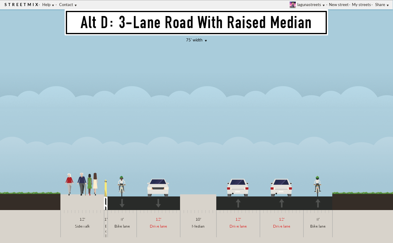
Here are street-sections of existing conditions at the project site. Four alternatives A-D show the sidewalk extension and address road improvements in the context of Complete Streets Policy. 

Alternatives C-D ensure all mobility modes are represented (walking, cycling, transit, private car) and all roadway users gain access to the public right-of-way (RoW). All views are oriented east-bound (uphill).

Temple Hills speed postings are 10, 25, 30, 35 miles per hour.


The alternatives strive to address all mobility modes to reduce congestion, reduce need for parking and improve safety

  • Preserves 36' existing right-of-way (RoW varies along TH Drive)
  • Improves sight-distance by lowering speed
  • Gains a crosswalk
  • Trades transit stop and parklett in place of parking
  • Combines 4 speed limits into 2, 25mph and 10mph
-LS

Thursday, April 16, 2015

Who Endorses Complete Streets Policy?

California Assembly Bill 1358


Chapter 657
An act to amend Sections 65040.2 and 65302 of the Government Code.


Overview
 A complete street is a transportation facility [roads} that  is planned, designed, operated, and maintained to provide safe mobility for all  users, including bicyclists, pedestrians, transit vehicles, truckers, and  motorists, appropriate to the function and context of the facility. Every  complete street looks different, according to its context, community  preferences, the types of road users, and their needs.


Overview  However, developing a transportation system primarily for motorized vehicular traffic has failed to meet the travel needs and preferences of large segments of the country's population.According to the National Complete Streets Coalition, established in 2005, complete streets are those designed and operated to enable safe access and travel for all users. Pedestrians, bicyclists, motorists, transit users, and travelers of all ages and abilities will be able to move along the street network safely.


Overview
The Enhanced Mobility and Complete Streets Transition Plan will outline a long-term vision for a city-wide transportation network that is pedestrian and bicycle friendly, reduces traffic congestion, and provides frequent and reliable transit service between home, workplace, school, recreation and shopping for residents and visitors. The plan would specifically focus on a balanced, multi-modal transportation network that meets the needs of all users of streets, highways, sidewalks and trails, including pedestrians, bicyclists, children, persons with disabilities, seniors, movers of commercial goods and users of public transportation, as well as motorists.

Thursday, April 9, 2015

The Proposed LCR Road Re-alignment Alternatives A-F

To meet motorist demand inevitable for Laguna Beach the city is reviewing a re-alignment for Hwy 133 Laguna Canyon Road. Alternatives A-E are proposed by the city consultant, Alternative F is proposed by the community.


Design Options: Multi-use Trail, Transit Lane (Dedicated)


Design Options: Multi-use Trail, Transit Lane (Dedicated)


====================


133 Task Force Proposal

Balanced Mobility Concept
  
Background Story:

Alternatives A-E were ranked by the city consultant for success by meeting a single criteria: the alternative that reduces car traffic delay the most wins (pg 24 of the Assessment).

Alternative F as proposed by the 133 Canyon Task Force moves the cycle-track from the highway into the wilderness park where it cannot serve residents across the highway.

Alternative F for 2030 seeks to balance all transportation modes and service the residents of Laguna Canyon Road.  This plan seeks to move people not just cars.

Alternative G is the gender-segregation option. Pink-Zone is inspired by the accident statistics showing the overwhelming majority of accidents are caused by men. See UK's Sheilas' Wheels here.


References: 

"Laguna Canyon Road Corridor Improvement Assessment (El Toro Road to Canyon Acres Drive)", RBF Consulting, 12 August 2014.

"Laguna Canyon Road Corridor Improvement Assessment (El Toro Road to Canyon Acres Drive)", RBF Consulting, 19 August 2014.

"Vision Laguna Final Report and Strategic Plan", December 2001.

Saturday, March 21, 2015

Monterey Drive Alternatives

On Tuesday 17 March LB City Council approved the roadway configuration shown in Alternative 2. For a host of reasons Alternative 1 is safer and the preferred alternative by neighborhood residents. Among the reasons are to combine vehicles with similar speeds in a shared lane and improve eye-contact with all roadway users, even dogs.
Monterey Drive at Jasmine Street before modifications
Shared unmarked pedestrain buffer

Resident preferred Sharrow separate walkway

Council selected shared multi-use bike/ped lane

Note: Traffic on Monterey Drive is one-way northbound.  -LS

Thursday, March 5, 2015

How to use Sharrows

Manhattan Bike Safety Sign, credit Drizzle Studios, Laguna Beach

Sharrows are reminders!

For motorists: the roadway is shared.

For bike riders: the safest lane-position.

Don't ride the  door-zone of parked cars like in this crash test.


Drive Safe
Ride Safe

Friday, February 27, 2015

The OpEd Unfit to Print

How Laguna Beach Got its Sharrows

What 8 years of community organizing failed to accomplish the LB City Council achieved by decree: 'Yea it Shall Be, Yea Verily it Shall Be Done!' The long awaited alternative bike-route through Laguna Beach will be completed in February. Every manner of community bike-rides, task force meetings, public workshops, firesides, potlucks and drum-circles tried but failed to inflate the agenda bill. But fear of litigation for compensatory damages (French, Pettis, Deem, Fitzpatrick, Colvin, the homeless ) brings municipal focus and commitment like a bike end-O. Last October our city committed to finish a bike-route, any bike-route, to improve street safety for LB cyclists.


But damn the torpedoes, design process, engineering review, stakeholders and those safety rankings from State collision reports, it's political engineering that gets stuff done in Laguna Beach. If you think these bicycle Sharrows are a miracle, wait till CalTRANS plows the Canyon HOV lane and the merry-GO-roundabouts. How 'bout a LCR bi-lingual bike and pedestrian pathway for Parents Without Partners?

Four of five OC Newspaper would not print this commentary.       -LS